Understanding World Regional Geography, 2nd Edition
By Erin H. Fouberg and William G. Moseley
Understanding World Regional Geography (UWRG), 2nd Edition, is a course designed to teach students to think and apply geographic concepts long after the course is over. Author Erin Fouberg draws from her expertise in geography education and research in student learning to create a product that has a strong pedagogical framework designed to engage students and deepen their understanding of the world by having them “DO” Geography.
The WileyPLUS online platform provides instructors with the freedom and flexibility to tailor curated content and easily customize the course with their own material. It includes the complete digital textbook, assignable questions, quizzes, and activities, a complete test bank, and a wealth of engaging online tools and resources, such as videos featuring vibrant imagery from all over the world and layered maps available through the dynamic environment of Esri ArcGIS Online. WileyPLUS allows students to easily interact with the content and provides them with opportunities to actively do Geography.
Schedule a Demo Request Instructor AccountWant to learn more about WileyPLUS? Click Here
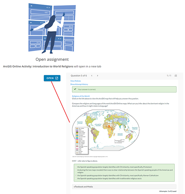
ArcGIS Online interactive maps transform learning.
UWRG was the first introductory course to integrate ESRI ArcGIS Online thematic maps, enabling students to engage with course materials, see patterns, and answer geographic questions. UWRG includes features that help students learn to read cultural and physical landscapes, ask geographic questions, apply geographic concepts, and make connections. ArcGIS Online Activities, available for assignment with each chapter, give students click-by-click instructions for manipulating the interactive maps in meaningful ways. The more students engage with these activities, the more they begin to think geographically.
Videos Bring the World to Life
A new series of Thinking Geographically Videos illustrates thirty pivotal, threshold concepts the authors spiral throughout the text. These videos help students think geographically—see patterns, read cultural landscapes, and question and explore how places are connected—as they learn about the world. Each concept is presented by author Erin Fouberg, with vivid imagery from all over the globe, and students apply these concepts in various contexts as they move through the program. Another series of documentary style feature videos explores current goings-on in the chapter’s region of focus.
Map Quizzes
These quizzes offer students a visual way to test their knowledge of regional cities, countries, and physical features.

Self-Scoring Practice
The Practice tab in Wiley Course Resources gives students a set of questions they can use for self-assessment as they explore the corresponding chapter section. The practice also allows students to see what they need to master before completing higher-stakes online assignments.
Pre-Created Assignments
Pre-Created Assignments in the Wiley Library save instructors time by allowing them to choose from a variety of pre-built Question Sets to use in assignments including ArcGIS Online activities and Map Quizzes. Instructors also have a wealth of questions in the Assignment Builder from which to create their own online assignments.
- Threshold Concepts: Across 14 chapters, the authors spiral 30 threshold concepts that help students learn to think geographically by applying them to their everyday lives. At the end of each chapter, each of the Creative and Critical Thinking Questions asks students to apply one or more of these concepts. WileyPLUS includes assignable essay-question versions of the Creative and Critical Thinking questions in the Assignment Builder with links to the Thinking Geographically Videos that support students’ internalizing of the associated threshold concepts.
- Chapter Openers: These feature a single photograph and a short vignette; the authors draw students into reading the chapter. The goal of each chapter opener is to get students to think about their existing perceptions of a region.
- Guest Field Notes: The authors invited colleagues to discuss their fieldwork-based research. Each guest field note includes a photograph and a vignette describing the fieldwork.
- Using Geographic Tools: This feature demonstrates, through real-world examples, how geographers use tools, including regions, mental maps, GIS, crowd-sourced maps, statistics, surveys, landscape analysis, and planning, to “do” geography. Each Using Geographical Tools entry includes a photo or a map and two Thinking Geographically questions.
- Reading the Physical Landscape: Students are walked through examining a physical landscape, identifying physical features, and understanding the processes that created the landscape’s features.
- Reading the Cultural Landscape: Students are walked through examining a cultural landscape, identifying the visible imprint of humans and cultures on the landscape, and understanding the processes that shaped the landscape.
- Your Turn: Geography in the Field: Students can analyze a photograph, make observations, ask questions, and think through answers. Each Your Turn: Geography in the Field feature includes at least two Thinking Geographically questions.
Key Features
Erin H. Fouberg is professor of geography and director of the Honors Program at Northern State University where she teaches courses in world regional geography, human geography, physical geography, geographic information systems (GIS), and political geography. She graduated from the Georgetown University School of Foreign Service and then earned her master’s and Ph.D. at the University of Nebraska-Lincoln (1997). Her research interests include the political geography of American Indian sovereignty, geography education, and sacred sites. She served as Vice President of Publications and Products for the National Council for Geography Education. She has co-authored four editions of Human Geography: People, Place, and Culture (with Alexander B. Murphy and H.J. de Blij, Wiley, 2006, 2009, 2012, 2015). She served as an editor on The Atlas of the 2012 Elections (with J. Clark Archer, Robert H. Watrel, Fiona Davidson, Kenneth C. Martis, Richard L. Morrill, Fred M. Shelley, and Gerald R. Webster, Roman and Littlefield, 2014) and co-edited The Tribes and the States (with Brad A. Bays, Rowman and Littlefield, 2002). Dr. Fouberg excels in teaching and advising undergraduate students, earning teaching awards from the University of Nebraska-Lincoln as a graduate student, from the University of Mary Washington in Fredericksburg, Virginia as an assistant professor, and from Northern State University in Aberdeen, South Dakota as an associate professor. She is active in her community, serving leadership roles on the soccer board, PTA, and fundraising campaigns for children’s charities. She enjoys traveling, reading, golfing, and watching athletic and theater events at Northern State.
William G. Moseley is a professor and chair of geography, and director of African studies, at Macalester College where he teaches courses on human geography, environment, development and Africa. His research interests include political ecology, tropical agriculture, environment and development policy, and livelihood security. His research and work experiences have led to extended stays in Mali, Zimbabwe, South Africa, Botswana, Malawi, Niger and Lesotho. He is the author of over 70 peer-reviewed articles and books’ chapters. His books include: An Introduction to Human-Environment Geography: Local Dynamics and Global Processes (with Eric Perramond, Holly Hapke and Paul Laris) (Wiley-Blackwell, 2013); four editions of Taking Sides: Clashing Views on African Issues (McGraw-Hill/Dushkin, 2004, 2006, 2008, 2011); Hanging by a Thread: Cotton, Globalization and Poverty in Africa (with Leslie Gray) (Ohio University Press, 2008); The Introductory Reader in Human Geography: Contemporary Debates and Classic Writings (with David Lanegran and Kavita Pandit) (Wiley-Blackwell, 2007); and African Environment and Development: Rhetoric, Programs, Realities (with B. Ikubolajeh Logan) (Ashgate, 2004). His fieldwork has been funded by the National Science Foundation and the Fulbright-Hays program. He has served as editor of the African Geographical Review, as a national councilor to the Association of American Geographers, and as chair of the cultural and political ecology specialty group. In 2011, he won the Educator of the Year award from students at Macalester College, and in 2013, he won the Media award from the Association of American Geographers for his work communicating geography to the general public via essays that have appeared in outlets such as the New York Times, Washington Post and Al jazeera English. Bill lives with his wife and two children in Saint Paul, Minnesota where he enjoys running, cross-country skiing and camping in his spare time.
Chapter 1. Introduction to World Regional Geography
Chapter 2. Global Connections
Chapter 3. Geography of Development
Chapter 4. Subsaharan Africa
Chapter 5. Southwest Asia and North Africa
Chapter 6. South Asia
Chapter 7. Southeast Asia
Chapter 8. East Asia
Chapter 9. Europe
Chapter 10. North and Central Eurasia
Chapter 11. North America
Chapter 12. Latin America and the Caribbean
Chapter 13. Pacific
Chapter 14. World Regions and World Cities